
Use your mouse to move the map area, and your mouse scroll wheel (or the "+" and "-" icons) to zoom in or out. Click on the streams and mines to find out more about them. There is a map legend immediately below the map.
The map above displays streams that are longer than 4.5 kilometers and are exceeding the maximum allowed pollution level under the Clean Water Act with the additional condition that they all have a low pH. The pollution levels trigger the TMDL requirements of that law. Many of the streams are located near abandoned coal mines.
Streams are regularly checked for a variety of pollutants. Action is required under the federal Clean Water Act when any of those pollutants exceed a certain level over an extended time interval. That level is the stream's "Total Maximum Daily Load," or TMDL. All the streams shown in the map above are exceeding their allowed level for at least one pollutant.
One especially difficult form of pollution is acidity. Acidity is measured by examining the percentage of Hydrogen ions in the water, known as "pH." When that percentage gets too low, the water is considered acidified. Many of the streams on this map have multiple forms of pollution, but they all are considered acidified.
These water pollutants can come from either point or nonpoint sources. A point source causes pollution at an identifiable location. An example would include pollution from a factory's outflow pipe or a coal mine's drainage channel or tunnel. Abandoned mine drainage would fall into this category. Nonpoint source pollution does not originate from a specific location and usually shows up in runoff after a rainfall. An example would be excess sediment entering streams off of farm fields and lawns.
Once the pollutants have been identified, the actual amounts of those pollutants are allocated among the various point sources and nonpoint sources. Then the maximum level of pollution that the stream can tolerate is estimated. The differences between the actual levels and maximum levels is calculated (including a margin of safety value to account for error) for each type of pollutant. Then they know how much each source has to be reduced.
The polluted streams are investigated by the individual states and reviewed by the US Environmental Protection Agency (EPA), who can order a TMDL analysis and recovery plan. The recovery procedures for point source pollution are carried out via the National Pollutant Discharge Elimination System (NPDES) program. Permits for plans to attain water quality standards get issued to the responsible parties. Nonpoint sources require a more complex approach due to the non-specific origin of the pollution. These sources require regulatory, non-regulatory, or incentive-based programs. Some examples include volunteer opportunities, cost-share programs, and EPA grants provided to the states.
The abandoned mines shown on the map above represent a fraction of all the mines in Pennsylvania. Coal mines are classified as either a surface mine (or strip mine) or an underground mine (or deep mine). Coal mines are found in two areas of Pennsylvania. In the eastern part of the state are the anthracite coal fields. Anthracite coal has a very high heating value, is used in the metal industry, and is also known as "hard coal." The western third of the state features bituminous coal fields. This very abundant coal is used in electricity generation and steel making.
Mines that are abandoned, like those shown on the map, are particularly challenging because there may not be an owner to sue for damages. In those cases, the state bears the responsibility for remediating that source. With such a long history of coal mining, Pennsylvania has a very large backlog of such remediation projects. Modern mines must comply with many regulations just to operate, and even more after operationa are complete and all the coal sought has been extracted. Older mines that operated before modern regulations and whose owners went out of business before the mines were safely closed are the most troubling cases.
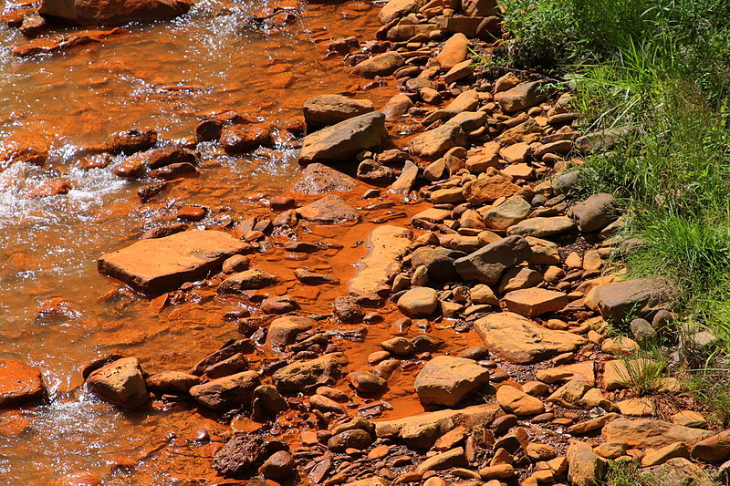
Coal contains varying amounts of sulfur as an impurity. Western Pennsylvania's bituminous coal contains more sulfur than eastern Pennsylvania's anthracite. Rainfall runoff that reacts with the sulfur creates a mild but ecologically damaging amount of sulfuric acid that makes its way into streams. The map above displays only those streams that have a TMDL caused entirely or in part by low pH levels, representing significant acidity. That acidity flowing into local streams causes harm to the stream ecosystem; for instance, a low pH can kill fish and reduce the hatching of fish eggs.
A guide to the meanings of the column headings is below the second table.
| Name | TMDL Name | Cause | Distance (Km) |
|---|---|---|---|
| Mahanoy Creek | Mahanoy Creek TMDL | METALS ; PH ; ALUMINUM ; IRON ; MANGANESE ; PH, LOW | 5 |
| Little Schuylkill River | Little Schuylkill River Watershed TMDL | METALS ; PH ; SILTATION ; TOTAL SUSPENDED SOLIDS (TSS) ; TURBIDITY ; ALUMINUM ; IRON ; MANGANESE ; PH, LOW | 2 |
| Lycoming Creek | Lycoming Creek TMDL | PH ; PH, LOW | 86 |
| Type | Status | Priority | Problem |
|---|---|---|---|
| Coal Deep Mine | Environmental Impact | Reclamation Complete | 90 Mine pool/Flooded deep mine |
| Coal Surface Mine | Health or Safety Impact | Reclamation Complete | 20 Dry Strip Mine |
| Coal Deep Mine | Priority has not been determined | Abandoned | 50 Underground Mine Fire |
| Rivers, Streams and Creeks Table | Coal Mines Table |
|---|---|
| Name: Name of the creek. | Type: Whether it is a surface or underground coal mine. |
| TMDL Name: Name of the Total Maximum Daily Load plan. | Status: Whether the mine has been returned to its natural state. |
| Cause: Why a TMDL plan is in place (usually multiple reasons). | Priority: Why the mine is a priority to be repaired. |
| Distance: Distance (in km) from the creek to the nearest abandoned coal mine. | Problem: The specific mine challenge (includes a code number). |